Grand Tetons Half Marathon – Jackson, WY (2015)

Saturday morning was an early morning (5:30am) to get ready for the race and be outside in time to catch the shuttle to the start line. My roommate, Franci, and I went out to the main parking lot and waited, and waited, and found some other people to wait with, started chatting, wondering if we were in the right place to catch the buses, started to get a little worried that somehow we had all missed the buses and then 5 huge school buses pulled into the parking lot and we were on our way to the start line!

The starting line was a great setup for the weather and number of people at the race – there were a ton of porta-potties and a heated tent so that we could get out of the cold morning air. There were also drawings every 5-10 minutes for random prizes, most including a digital image package and the grand prize being a free entry to another Vacation Races event in the next year.

  • Mile 1 – 10:57
  • Mile 2 – 10:51
  • Mile 3 – 10:03
  • Mile 4 – 10:45
  • Mile 5 – 10:58
  • Mile 6 – 11:34
  • Mile 7 – 11:28
  • Mile 8 – 10:16
  • Mile 9 – 12:19
  • Mile 10 – 12:37
  • Mile 11 – 12:15
  • Mile 12 – 14:41
  • Last Mile – 11:56

Official time: 2:35:19

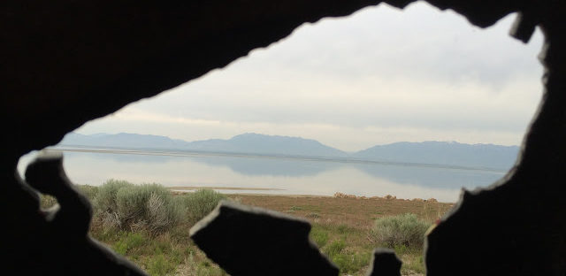
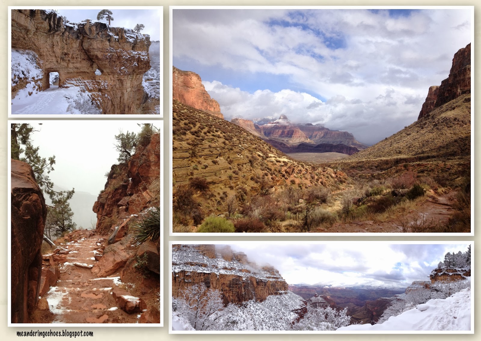
The scenery for this race was amazing! The race had an overall elevation gain of a little over 400′ but with the elevation change coming from the east coast, I felt winded pretty early in the race (I was told to expect this, but it’s still a little bit of a shock when it happens). I did a 4:1 run / walk ratio again, starting after the first mile and adjusting for the times when I stopped to take fun pictures – miles 9-12 were the most scenic part and I definitely stopped to take lots of pictures.


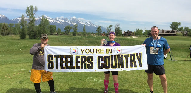
The finish line festival was at a local golf club and we got free pictures from the race photographer with our medals (above). The finish line festival was relatively small, but as you came across the finish line, there was an announcer who tried to get everyone’s name as they came in and after getting our medals, we went into another tent that had our boxes of goodies, bananas, water / Nuun and lots of folding chairs to sit down if you wanted to. Since this was a point-to-point race, this was also where we could pick up our drop bags. After grabbing some food, I headed back outside, got my free finisher picture and randomly saw some guys holding a “You’re in Steelers Country” sign and I immediately ran over and asked if I could photobomb their picture! They were happy enough to oblige and as soon as I got my picture, another woman came over and asked if she could get her picture too because she was blogging about her experience for UPMC (University of Pittsburgh Medical Center). 


After the race, I caught back up with Franci and found out she had gotten 3rd place in her age group and beat me by about 5 minutes! The age group winners got a gold / silver / bronze version of the same medal that everyone received and they looked really awesome!

The only complaint I have about the race is the miles that we were on the dirt road, while they had sprayed to try to cut down on the dust, it wasn’t closed to traffic, so it made it hard to breathe when a vehicle would pass and kick up a bunch of dust. Plus, about a mile or less from the finish line, I had a bus do about a 15-point turn in the middle of the road in front of me which required me to stop until he got situated and facing the other direction. That part was really frustrating since the bus driver could clearly see that there were runners still coming down the road and because this was someone that the race organization had hired (the buses took us back to the start line / original pick-up location).

Overall, I would definitely do this race again, if nothing else to have another excuse to head back to the Tetons! 


Westward adventures – Antelope Island, UT

After doing a quick stop-off at REI and Target for some last-minute items (bear spray, cooking fuel, Cheez-Its, Poptarts – all the good stuff!), I headed north of Salt Lake City to Antelope Island. I booked a campsite on the island so that I could take some time in Utah before heading up to Wyoming for a week’s worth of adventures. The guy working the front desk at my hotel in Salt Lake didn’t seem too impressed that I was heading up there, but it turned into a great experience! 

My first stop was the Lady Finger Point Trail which was just a short trail (about half a mile total) out to see the Great Salt Lake and all of the seagulls who were nesting in the area.

Next stop was the visitor’s center which had some tributes to the bison of the island.

The island had some very pretty flowers growing on it.

I also did a quick trip around Buffalo Point Trail (a little less than a mile). 


The big hike for the day was up to the top of Frary Peak Trail (about 6 miles total with 2,084 feet of elevation gain). Of course, I waited until the hottest part of the day to start this hike, but I took it slow and there was a ton to see.


After that hike, I took a driving trip around the rest of the island and you could see the skyline of Salt Lake City.

The other great part about being on a lake is that you can usually get some pretty good sunset views.


Friday morning I got up early and I was able to see a lot more bison roaming around the island. There were a few out Thursday afternoon, but they were much more active Friday morning, including crossing the road right in front of my car.


Even though I only stayed on Antelope Island for one night, I would definitely encourage you to take a trip out there if you have the option. I would highly recommend long sleeves and a head net for the bugs – the biting gnats had hatched by the time I got there, so they were quite annoying, but the head net worked really well.

Tourist time: Nashville

Last weekend wasn’t my first trip to Nashville, but it was my first trip downtown. Apparently the last two times I went, I didn’t make it too far out of the Opryland comfort zone of my work conference. Other than the race, I only really spent Thursday night downtown. As I’ve mentioned before, I’m a huge hockey fan and one of my goals is to eventually make it to all of the arenas in the league. I’ve already checked off quite a few (including four in a tour de hockey in 2013), so when I realized that the Predators would be playing in Nashville the day before I was planning to drive up, I knew I wanted to try to get a ticket to the game! Unfortunately, the Predators locked down Ticketmaster sales so that you could only buy a ticket if you were in their viewing area, which includes the states that surround North Carolina, but not actually North Carolina because we have the Hurricanes for our hockey team. I called their box office and was very rudely told that I should find someone else to buy the ticket for me and when I explained that the only tickets available on Ticketmaster were for credit card entry only, the “customer service” rep said “well, I can’t sell you a ticket.” I called Ticketmaster and their customer service rep was much nicer about the situation, but unfortunately still couldn’t help me. I kept trying to buy a ticket online, but didn’t have any luck and then Wednesday night, all the tickets were all gone from Ticketmaster (apparently they opened up ticket sales 24 hours prior to the game and promptly sold out). So, instead, I headed to StubHub and got myself a ticket. 

Thursday morning I headed out early to get to Nashville in the late afternoon and after a quick stop off at the race expo, I headed back to the hotel for a quick nap before the game. Due to the TV schedule, the game didn’t start until 8:30pm local time, so I was able to get a good nap in before heading back downtown. While I was there in the afternoon, there were a lot of people wearing Blackhawks jerseys, but by the time I made it back down that night, the street had turned into a sea of yellow jerseys. 


It ended up being a great game, with Nashville taking the win and forcing a game 6 on Saturday night. In my previous trips to Nashville, I wandered around the Parthenon in Centennial Park.

The park includes Lake Watauga,


and a statue of John Thomas who was a businessman and President of the Tennessee Centennial and International Exposition in 1897.


Plus, there’s also the only surviving Nashville, Chattanooga and St. Louis Locomotive #576,


and some designer fish as well.


Most of my time in Nashville has been spent at the Gaylord Opryland & Convention Center which is an amazing building, with two atriums inside. In the two weeks I was there for work conferences, I think I only wandered outside once or twice, but I never felt confined indoors within the massive building, which includes its own indoor boat tour through the atrium. Unfortunately, I don’t have any pictures of the atrium, but it’s definitely a place I would recommend checking out if you’re up in that vicinity. 

What’s your favorite place to visit in Nashville?

Tourist time: Washington, D.C.

Since our hotel was right next to the Metro station, it was an easy place to start our tour of Washington, D.C. The first stop was the White House – it wasn’t very crowded when we got there first thing in the morning, so we were able to take a few pictures before heading to the mall. 

From the White House, we wandered over to the mall and as we got closer to Constitution Avenue, we saw the cops had the road shut down and there were bleachers on the side of the street – it took us awhile to figure out why, but more on that later. On our way to the Washington Memorial, we passed the German-American Friendship Garden and even though it was a little too early for the plants in the garden to be blooming, it has a beautiful memorial as well.

It was fairly cloudy when we were wandering around, but the blue skies tried to peek through at times and I was able to get the great picture below of the Washington Monument by sheer luck as we had stopped and as we did, a flock of geese flew in front of the monument.

From the Washington Monument, we headed over to the Lincoln Memorial. Unfortunately, the reflecting pool hasn’t been filled yet, but we were able to get close to the Lincoln Memorial even though it was the most crowded part of the mall.

After touring the mall, we headed back to Constitution Avenue to see the start of the St. Patrick’s Day parade! As I mentioned, it took us awhile to put all of the pieces together to figure out why the cops had blocked the road, added a set of bleachers and why there were so many people dressed in green all over the place! There were a lot of old-school police cars and firetrucks, several bands, including some bagpipers and Irish jig dancers. A very cool accidental way to spend the morning.

One of the final places we saw before heading back home was St. Patrick’s Church on 10th street – a fitting way to end St. Patrick’s Day weekend in DC!

What’s your favorite place to visit in Washington, D.C.?

Tourist time: Lynchburg, VA

Downtown area near the Blackwater Creek Bikeway & Riverwalk

More downtown views
Left top & middle: Amazement Square, Children’s Museum
Left bottom: Liberty University logo on the side of a mountain

Lots of churches and a HUGE hill that I was very grateful was not on the race course

Memorials for Lynchburg soldiers including a stone in memory of 43 unknown Confederate soldiers

Beware the weeping angel in the graveyard of Lynchburg – don’t blink!

Tourist Time: Lexington, KY

This post is a long time coming, but I travelled to Lexington so that I could Run the Bluegrass half marathon and check Kentucky off my 50 states running list back in March. Since the half marathon was on a Saturday, I drove in on Friday in order to pick up my race packet and get settled at the hotel. Saturday’s weather was really rainy, so after I took my post-race nap, I headed out to see what I could find downtown. 

I didn’t really plan anything specific to do while I was in Lexington and my afternoon nap meant I didn’t leave the hotel until about 5:00, so there weren’t too many shops open downtown by the time I started wandering around. One recommended place to visit was the Old Kentucky Chocolates at Lexington Center. There weren’t too many shops still open when I got there, but I wandered around a bit and did find some good treats. The building is connected to more shops across the street at the Victorian Square Shops, so I was able to check out that building as well (left picture below), but again, there wasn’t much open, so I just wandered around the building for awhile before heading back to my car. The numerous stairways in the building reminded me of an Escher painting, but due to the lighting, I really couldn’t get a good picture of them, but you could look over the side of a railing and see stairways everywhere and occasionally you really had to look to figure out where they came from and make sure they weren’t just stairs to nowhere!

On my way to my next stop, I ran across the Lincoln mural and it is definitely striking as you drive down the street in an otherwise pretty standard landscape of buildings. Apparently the mural is only about 6 months old and I found a time-lapse video showing the creation of it last November. The mural is on the back of the Kentucky Theatre and apparently there are several other murals in other parts of the city, but I didn’t see any of those.


While I still had a little bit of daylight left, I wanted to check out Thoroughbred Park where they have statues of a “photo finish” as well as some frolicking foals and a tribute to Civil War-era horse, Lexington, who represented the city in the 1854 Great Post Stakes in New Orleans. 


Sunday I did a little bit more wandering around to the colleges in the city. Since the University of Kentucky officially killed my NCAA bracket while I was in town, I thought it was fitting to check out a little bit of their campus. Even though the weather was better Sunday morning, I still had a long drive home, so most of my sightseeing was done via my car. After that, I had to check out Translyvania University since I had seen so many signs for it around town and I found a single room log cabin which was built by Colonel Robert Patterson in the late 1700’s and became part of Translyvania University in 1939. 


Have you ever been to Lexington? What else should I have visited while I was there?

Tourist Time: Key West, FL

The weather was perfect for our trip. Although it was really hot during our run, it was nice to be able to walk around in temperatures in the high 70’s. Since we had 12 people to accommodate, we rented a condo at Pelican Landing for our team and it was awesome! We had a full kitchen where we were able to make breakfast every day and a living room to chill in at night. This picture is from our huge balcony!

As part of the Ragnar Relay, there was a sponsored bar crawl that several of my teammates wanted to participate in, so on Sunday, we headed out to wander around downtown to do some barhopping. Our first stop was Charlie Mac’s which has an area where you can take a mug shot with various “crimes” listed, where our team was more than happy to grab some candid photos. As we continued on our bar crawl, we came across the Southernmost Tattoo shop, which prompted several of us to check in on Facebook and with the help of the temporary tattoos provided by Ragnar, we were able to scare a lot of relatives back home! We spent most of the day on Sunday just wandering around Duval street and I would highly recommend it if for nothing else than people watching. There really is something for everyone on that street – just be aware that you’ll be surrounded by lots of people drinking! Key West has a very lax (nonexistent?) open container law, so I was highly entertained the entire evening.


Here’s a view of some of the sunsets we saw, the one on the left and the top right are from the finish line at Higgs Beach and the bottom right is from Mallory Square. 

The first night we were in town, we wandered over to the southernmost point. I wanted to go back during the day to get a better picture, but we spent our last day on the beach and by the time I remembered, it was already dark again! The Green Room Milers (team #270) asked us at one of the exchanges if we were ready for the swimming portion of the race which started in Key West – only 90 miles to Cuba! 


Monday we spent the day hanging out on Smathers Beach and enjoying the beautiful scenery.


On our way back to Miami, we stopped to take some pictures at 7 mile bridge which is much less intimidating riding in a van with AC! 

My final picture isn’t really of Key West, it’s actually from the plane as I was flying into Miami, but I really like the outline of the beach and the colors of the water, so I had to include it here! 

The one thing I wish I would have gone to see while I was in Key West was Hemingway’s house, but, just like the southernmost point picture, by the time I remembered it, it was late on our last night and I was ready for sleep! 

Have you ever been to Key West? 

2013 Throwback – Arizona road trip part 2

Yesterday, I started reminiscing about my trip to Arizona last year, so today I’ll finish off the recap of the Grand Canyon and then take you through Sedona and Scottsdale. 

After doing part of the Kaibab Trail, I had a really long debate with myself about whether to go back and finish the trail (to Skeleton Point) or to try out another trail. I ended up choosing to do another trail and this one started right outside of the lodge I was staying at, so as soon as I finished breakfast, I was able to get my pack ready and head out the door. Since I had all day, I decided to hike the Bright Angel Trail and head down to Indian Garden (4.5 miles down). The layers of snow made for some beautiful pictures. The top left picture shows the first of two “tunnels” through the rock that the trail takes you on. The bottom right picture shows a wide angle view from near the top of the trail where there is still a lot of snow, but the bottom left picture shows what happened as I continued on the trail – the farther I went down, the less snow there was and the more the temperature rose. I started out hiking in my ski jacket, but as I descended, I was able to shed that layer and stay warm enough. Right before I got to the 1.5 mile rest house, I saw some horses coming up the trail, so I moved off of the trail into a little stone building that sheltered me from the weather. Unfortunately, one of the horses was not happy on this section of trail, so I had to wait quite awhile before they were able to pass. Luckily, the rider was able to keep the horse under control enough that no one got hurt and they were able to continue on their journey as well. The top right picture is a view as I was getting closer to the Indian Garden. By this point, all the snow was gone and the trail had flattened out. 


One thing I learned is that my camera does not like to be dropped in the snow (who knew?) but if you do that sometimes you end up with some really interesting effects, like this picture:

From the Grand Canyon, I headed south toward Scottsdale by way of Flagstaff and Sedona. I didn’t spend too much time in Flagstaff, but it was cheaper than staying in Sedona, so I spent the night in Flagstaff and then left early to check out Sedona before I had to be in Scottsdale. After seeing Sedona, I wish I would have spent the extra money to spend the night there – it was beautiful! Because I had left so early, I was able to get the sun coming up over the red rocks and even caught the moon in a few of my pictures. 


In Scottsdale, I was able to get some more hiking in at Pinnacle Peak. The weather was much warmer in Scottsdale and the scenery is completely different! The cacti are huge! The one in the top right picture is probably over 100 years old and maybe even over 175 – there’s a growth chart on the trail that shows an estimation of how big a cactus is at various points in its lifecycle. 


I hope you’ve enjoyed my trip down memory lane through Arizona. Have you ever been to Arizona? 

2013 Throwback – Arizona road trip part 1

Vacation Races held a contest on Monday for a free race entry to one of their national park series race events this year in honor of the first entrance-fee free park days. Unfortunately, I did not win a free entry to the race I chose (Grand Canyon), but it did get me thinking about my first trip to the Grand Canyon which I took around this time last year. I was able to spend a week in Arizona and made a road trip out of it – I flew into Phoenix (and caught a hockey game, of course), then drove up to the Grand Canyon and stayed there for 2 nights, then headed to Flagstaff for a night and finally made my way through Sedona to Scottsdale for 2 days. It was an awesome trip and I can’t wait to go again!

I really didn’t know what to expect from the trails at the Grand Canyon – I’ve done a few hikes by myself, so I felt comfortable going alone (though I’m not sure my family felt the same way!) but I wasn’t sure how I’d react to the elevation change – 750′ in Charlotte to 1,100′ in Phoenix to over 7,200′ at the Grand Canyon! Luckily, I didn’t have any physical issues, though the change in elevation did create some interesting weather conditions.

I got there around lunchtime and started at the main visitor center. I took the Rim Trail until I got to the South Kaibab Trail  which was about 2.5 – 3 miles. The weather was great for this part of the trip – it varied between sunny and overcast with some sprinkles, but that meant I got to see lots of rainbows. I would highly recommend taking the Rim Trail – it’s a paved path that does have a few “uphill” sections, but they’re minor and there are a lot of great opportunities to take pictures. I took all of the pictures with either my iPhone (great for panorama’s) or my actual camera, which is how I got the pictures of myself during the trip (thank you 10-second delay!).


When I got to the South Kaibab Trail, there was a few inches of snow on the ground and it was a pretty steep trail, so I put on my shoe spikes and started down the trail. I decided that I would just take the trail as it came and just go as far as I thought I could manage. Starting with the top-right picture is a view of the trail I was heading down – lots of switchbacks and definitely steep! The bottom-right picture was my favorite part of the trail – it’s a section of trail that is surrounded by super steep drop offs on either side. It’s frightening and exhilarating all at the same time! I was comfortable walking this trail, but there is no way you could get me on a horse to go down these trails!! The bottom-left picture is another view of the trail looking down from Ooh-Aah Point (.9 miles down the trail) toward Cedar Ridge (1.5 miles down). I made it to Cedar Ridge before deciding to turn around since it was getting later in the afternoon and I didn’t want to get stuck on a trail as it was getting dark. The top-left picture gives you and idea of the expansiveness of the view – it really is breathtaking.


Monday morning I got up early to head out to try to catch the sunrise and was shocked by what I found outside – about 6-8″ of snow! At this point, I was glad I let the rental car company convince me to get the 4 wheel drive. I bundled up and headed out toward the west side of the Rim Trail toward Hermit’s Rest. I wasn’t ever able to get a great picture of the sun coming up, but it was really neat to see the clouds slowly disappear as the sky lightened. The top left picture is one of the early ones that I took – you can really see the clouds hanging in the air. With all of the clouds in the canyon, you could see how fast the wind was moving.The next two pictures on the left are once it started to clear up a bit and you could see the snow in the canyon itself. I really like these as it shows the steepness of some of the drops (where none of the snow stuck) as well as the elevation change where you can see the snow just stops. The top right picture is at the far west end of the Rim Trail at Hermit’s Rest and the bottom right picture is from one of the lookouts on the Rim Trail – it’s funny how the panorama ends up distorting some of the image, but it’s fun to see the change in sky color throughout the picture. It was really quiet when I went out, which was to be expected as I didn’t see that many people when I was out in the middle of the day on Sunday, so I didn’t expect to see many this early in the morning. 


Tune in tomorrow for more trail pictures and a recap from Sedona and Scottsdale!

Have you ever been to the Grand Canyon?

Tourist Time: Charlotte, NC

I’d like to start off the new year by showing off my current city. After writing my previous post on the best tourist attractions in every state, I started thinking about how you always take the city you live in for granted and don’t necessarily ever get into the “touristy” things because, well, that’s what everyone else does when they come to your city. With that in mind, here’s a few things that you should definitely check out if you ever find yourself in Charlotte.


This is really only a couple block radius in uptown, so there’s a lot of Charlotte that I haven’t highlighted, but it’s a fun place to wander around. What else should I add to this list?