Tourist time: Oregon day 1 – Multnomah Falls

Tuesday morning (September 1), I flew from Albuquerque to Portland via Phoenix, which is a surprisingly long flight, and started on the second-half of my adventure – Oregon! The Oregon trip was thoroughly (overly?) planned as there were so many things I wanted to do while I was there and I only had 6 days to fit everything in! There was going to be a lot of driving on this trip, with every day having at least 2-3 hours and sometimes more depending on what was next. 

First up was a drive from Portland to Bend via the scenic route around Mt. Hood. The first stop was Multnomah Falls, about 45 minutes east of Portland. It was a good place to grab lunch and stretch my legs with a short hike. It was fairly cool, so I was just dressed in jeans and a t-shirt, which was regrettable very shortly into the hike, an uphill jaunt to the top of the falls. One of the best views of the falls is easily accessible from visitor’s center, so you wouldn’t need to hike if you didn’t want to.

The good news about the hike to the top is that there are switchbacks to help cut down on the steepness, but the bad news is that there is a ton of them!

Despite what the sign says, there were definitely more than 11!
 
The path is also paved, which makes it a little bit of an easier walk, but I was still pretty slow during the hike and was regretting the choice of jeans as the trail kept going up.
 
 
The view from the top of the waterfall isn’t nearly as exciting as the first view from the visitor’s center, but you can see just how far you hiked (the upper falls are 542′ and the lower falls add another 69′) and how small the parking lot is. 


You can also get a good view across the Columbia River to Washington.


After the falls, the rest of the drive down to Bend was fairly uneventful. There was a ton of fog around Mt. Hood, so it was hard to see up close, but after exiting the national forest, I got a great rearview mirror look at the top of the mountain rising out of the fog. Next time I head to Oregon, I will make sure to add an actual trip to Mt. Hood to the list! There were a few more mountains dotting the horizon on the way to Bend, and as the sun was setting, the Three Sisters came into view.

 
Wednesday’s adventure: hiking South Sister mountain!


Tourist time: New Mexico day 2

Since I was spending an extra day in New Mexico, I rented a car so that I could wander around on Monday. I checked into my hotel and picked up a few tourist pamphlets from the lobby to try to figure out what I wanted to do. I knew I wanted to check out Route 66, but that was the only specific thing on my agenda. 

Monday morning, I had decided to check out the singing road and take the scenic route towards Santa Fe. It was interesting and I could definitely hear it, though I wouldn’t recommend going out of your way just to drive that section of the highway.

My next stop was Sandia Mountain. Originally I was going to take the tram to the top, but I ended up just driving up to the top and then hiking a few of the trails. The summit is 10,378′ and the views are simply amazing. I spent some time just sitting there looking at the surrounding city. 


The mountains don’t extend very far, but you can see for miles. When I was sitting up there, I could understand why people do paragliding and base jumping. From the top you feel like you could fly forever. 


After hike around the summit trails, I headed to the Kasha Katuwe Tent Rocks. It took me awhile to get there, and by the time I did there were some storm clouds brewing, but they were still in the distance and it was only a couple mile hike, so I grabbed a water bottle and headed onto the trails.


I passed quite a few people coming back who were surprised that I was starting out my hike, but I told them I would go as far as I could while the storm held out. At first, the trail is wide open and slowly gets more and more narrow as you climb into the rocks.

Some of the sections got really narrow and you had to climb over rocks to continue on the trail. It was about this time, when I could still hear thunder in the distance, that I thought this would not be a good area to get caught in if it really started to rain. 

I made it about half a mile from the end of the trail before it started to rain / hail and the lightning got a lot closer, so I decided it wasn’t worth it to keep going and I turned around. I passed quite a few people who were hiding out under some of the rock ledges, but given the rain storms that came through Angel Fire on Friday and Saturday, I wasn’t willing to risk sticking around. 

As I got back to the wider section of trail, the thunder backed off and as I came to a fork in the trail, I decided to take the opposite way from where I had come since they both lead back to the parking lot and the new way was only .2 miles longer. Within a few minutes, the rain and hail were done and the sun came back out again, but I didn’t want to retrace my steps, so I just kept going and enjoyed the new views.


One of the reasons I wanted to check out this section of the trail was because there was supposed to be a “hole in the cliff” interest point. This was certainly an aptly named attraction.

I also came across one of only a handful of cacti that I had seen my entire time in New Mexico. I had (erroneously) assumed that the New Mexico landscape would be similar to Arizona and there would be cacti everywhere, but they were few and far between.


Eventually, I made it to the tent rocks and just before I did, the rain and hail came back with a vengeance, so I snapped a few quick pictures and then turned my hike into a trail run back to the car.


yes, all that white stuff in the picture is hail

After the tent rocks, I made my way back to Albuquerque and spent the rest of my night grabbing some food and re-packing all my stuff for my next adventure in Oregon.

Tourist time: New Mexico day 1

Sunday morning (August 28), a couple of us decided to try out the zip lining available at the resort, so we bundled up and headed out into the early morning fog.


The base of the resort was around 8,500′, but the top of the mountain was over 10,000′ so we took the chair lift up to the top. It was a fun ride and we could see a lot of the Red loop that we had all run in the days before. There were mountain bikers on the trails for their own race and we got to see them flying down the hills. At first the chair lift was a gradual climb, but as we got closer to the top, it got steeper and steeper.


There were 4 guys in our zip lining group and we got to tell them about our running adventures after they told us they had seen lights running up and down the mountain all night and wondered what that was all about. They were definitely impressed that we had been part of that. A little less so when all 3 of us had to stop to catch our breath as we were walking from one area to the next. They asked, “didn’t you just run up these hills?” Well, yes we did – that was part of the problem! There were 2 small lines around 200′ each, a few in the 600-700′ range and a really long one at 1600′ where we were told we would hit speeds of 50-60 mph. I definitely believe that as my eyes were watering on that one! Overall, it was a great choice for a random event on a Sunday morning.


After we checked out of our condo and said goodbye to the resort, we headed down to Taos for lunch and to wander around the city for a bit before heading to the spa for some much needed relaxation after our race. Looking back at mountains as we were leaving was even more impressive and you can see why this is a popular ski area in the winter.


On our way to the spa, we stopped at the Rio Grande Gorge Bridge.


Seeing the Rio Grande reminded me of my trip to the Grand Canyon a few years ago. It’s hard to fathom how these areas were created, how long it must have taken and how much of our world is always changing.

It was a beautiful day and even though it was late afternoon by the time we got to Ojo Caliente Mineral Springs Resort it was still pretty warm and we all took advantage of the mud baths and various hot springs available. It was a really pretty area. The spa was built into the side of the mountain, so all you could see is beautiful scenery all around and the entire spa was a “quiet zone” where you had to whisper, so it was very peaceful. 

a slightly out of place telephone box… if only it was blue!

The spa did wonders for our aching legs, but the early start to the day and warm water made me very tired. We still had a couple of hours to go before we got back to Albuquerque, so we got a great sunset view over the mountains as we traveled.


We finished off the night at Marble Brewery before we all headed our separate ways. Some of the team was heading back to Charlotte on a red-eye and the rest of us were heading in opposite directions for our last day or so in New Mexico.


One more day in New Mexico for me before I head off to Oregon!

Westward Adventures – Coming to a close

Monday night at the campground was interesting. I knew from checking the weather that there were potentially going to be some storms coming through, but the weather throughout the Tetons and Yellowstone was hit or miss, so I set up my tent and then went about cleaning up and reorganizing all of my gear. Living out of a car / tent / backpack for two weeks can create a bit of chaos when trying to figure out how to make it all fit back into a suitcase and checked bag. I started a fire, made some dinner and went about burning my extra cardboard and gathering all of my garbage from the car, but before too long, it started to rain big drops and as I heard the thunder getting closer, I put out my fire and climbed into my tent. The rain let up around 8:00pm, so I ran out to brush my teeth and then headed back into the tent for the night. It was a downpour for a lot of the night, complete with thunder and lightning. In hindsight, I should have just slept in the back of the SUV, but by the time I thought about that, I was already barricaded in my tent and everything was getting wet, so there was no point in trying to pack it all back up again. Instead, I listened to the sound of the rain and had another early night.

The great news about having the SUV was that I was able to lay out my tent (and anything else that got wet) over the passenger’s seat, back seats and even into the back to let it dry out before I had to pack it back up for the airport. That definitely proved to be very helpful on this trip! Starting out early, along with all of the rain the night before meant another morning full of fog and extra steam as I made my way through the park one last time.

In addition to less traffic, it was another great morning for bison sighting, with herds lined up along the road.


One stop I made was at Fountain Paint Pots in the Lower Geyser Basin. There were huge signs everywhere about how dangerous the area was. 


The fog stuck around for this first stop and made for some great pictures.


Each of the thermal areas had their own names – first up, Celestine Pool. 


Next up, Red Spouter


followed by Leather Pool,


Fountain Paint Pots


and Silex Spring, which you can actually see a little of the blue color from the road,


and finally, there is Bacteria Mat.


My last stop in Yellowstone was the Fairy Falls trailhead. I didn’t go too far, just far enough to check out the handiwork of a local spider,

and the beautiful bridge.


There are also a few thermal features that feed into Firehole River. 


I couldn’t resist one last view of the mountains as I made my way back through Grand Teton National Park. I absolutely fell in love with the Tetons – you really can’t beat the views in that park and I can’t wait until I can go back again!


Since my flight wasn’t until midnight Tuesday night, I took my time wandering through Wyoming (and a little bit of Idaho) before going back to Utah. Having travelled mostly through Idaho on my way to Jackson Hole, I decided to go the other route this time, but I would definitely recommend the Idaho route – you get much better initial views in the mountains, literally an up-and-over-type drive – whereas heading mostly through Wyoming takes you through very remote areas and small towns.

As I was crossing from Idaho back into Utah, I got to drive around Bear Lake and outside of Garden City, the road climbs to a great overview of the lake.


The rest of the trip back into Utah was uneventful and even though my flight was delayed by about 20 minutes, it was a much easier ride out of Salt Lake City than heading in and I quickly fell asleep. I did wake up in time to see the sunrise in the air as I made my way back to Charlotte.


It’s been about 1.5 months since I started on this trip and I’m still trying to wrap my head around everything that I got to experience. When I first started planning this trip, after everyone got over the fact that I was going to be running two half marathons and hiking in between, their first question was always, ‘who are you going with?’ and I never had a good answer for that. I saw the half marathons and immediately signed up – 2 states in a week is too good to pass up! After that, I just started reading about what I could do while I was out there – I never put much thought into the fact that I would be hiking by myself. I read up on the dangers of wildlife (bison and moose and bears, oh my!) and put in several months of hiking as training. This was not my first time backpacking alone (though last time I did have my dogs with me) and I felt confident in my abilities, including how much hiking I would do, how heavy my pack was and the terrain I would be traveling in. I also did a lot of research on food to eat, what equipment I needed and even bought a gps phone to have in case of emergencies. I loved every minute of this trip and I can’t wait to take another one!

Westward Adventures – Old Faithful, Natural Bridge, Grand Canyon of Yellowstone, Artists Point and Uncle Tom’s Trail

After getting to bed early Sunday night (around 9:30), I got up early on Monday morning to make the trek to Old Faithful. My goal was to get there early enough to beat some of the crowd that I had seen on my first drive through Yellowstone. Part of the road from Mammoth to Old Faithful was under construction, so there were some short delays, but nothing too terrible. Since I left so early in the morning, it made the steam and fog rising from the thermal areas much more dramatic than you would see in the middle of the day.


When I got to Old Faithful, the parking lot was already pretty crowded, but I found a spot and then headed to the main attraction. There were already a lot of people sitting in the benches near Old Faithful, so I figured I would stick around there until it erupted and then wander around the rest of the shops after. I only had to wait for about 10-15 minutes before it started to erupt.


This ended up being a fun place for people watching because there were a lot of selfies being taken during the eruption and huge groups trying to coordinate their own pictures. I really couldn’t have timed my arrival any better because I beat a lot of the crowd and didn’t have to wait too long and then I was able to continue on my journey through Yellowstone.

Next up was the natural bridge which is exactly what it sounds like – a bridge made out of stone. Water washed out the rock from below and left a bridge with even a tree growing on top!

From this picture, you can see how small people on the main trail are. I didn’t actually come up that direction, so I made a loop out of the trail and got an even better picture from the bottom of the trail.

From the natural bridge, I headed to the South Rim trail which includes the Grand Canyon of Yellowstone and Artists Point. While it was a little bit more crowded here, the views were absolutely amazing. The pictures that I took don’t even look real!


Part of the South Rim trail leads you to Uncle Tom’s Trail which is very, very steep, but leads to a great waterfall view. I even got to see a few rainbows the day I was there.

There are 328 steps to get to the bottom platform of Uncle Tom’s Trail, which means another 328 steps to climb back up to the top!

From the South Rim, I headed to the North Rim trail which was much more crowded, at least at first. Everyone wanted to parked in the first parking lot which caused a lot of backup, but the second parking lot had a ton of open spots, so it was easy to grab a spot there and check out the views from that side.


After the North Rim trail, I headed back to the Madison campground for the night… only one more day until I head home.

Westward Adventures – Upper & Lower Terraces, Hellroaring Creek & Mt. Washburn

Sunday was a very busy day. Since I was starting out in Jackson Hole, I had a really early start (6:30 am) and was planning to stay in either Tower Falls or Mammoth. I made it up to Tower Falls around 10:30, but it was full (or possibly still full from the night before), so I drove up to Mammoth and secured my campsite for the night. When I checked in, they warned me to be aware of the elk in the area because there were a ton of calves around and the mothers would charge if they felt threatened. They weren’t kidding about all the elk – they were everywhere! They didn’t seem to care that there were cars and people everywhere and just kept eating grass and wandering around. I got an early lunch at the cafe and then walked to the Lower Terraces.

As you approach the terraces, the first thing you see is the Liberty Cap which was created after a hot spring plume stayed open and the mineral deposits just kept building into what you can see today.


I ended up wandering up to the Upper Terraces too, but those steps still hurt to do! The Upper Terraces gave great views out across all of Mammoth.

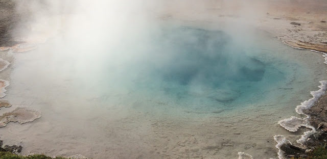
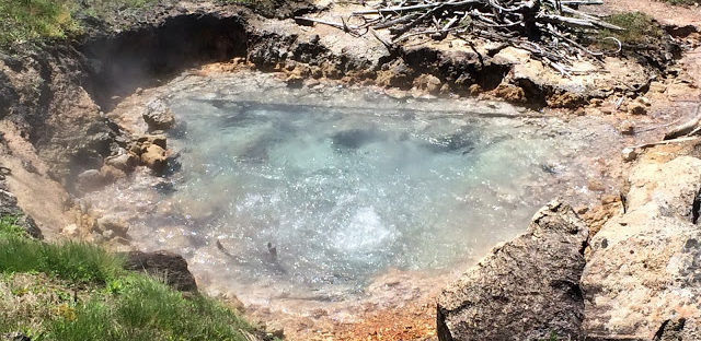
 The colors in the different springs were amazing – lots of oranges and browns here in comparison to the blues and greens from the Artists Paintpots.


There were a lot of trees and bushes that were taken over by the hot springs and were in varying states of calcification.

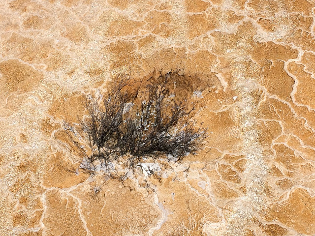
The stark contrast of the white mineral deposits made the active hot springs even more prominent across the landscape. 
 

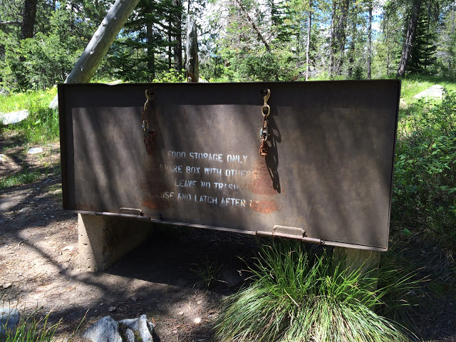
After the terraces, I headed to Hellroaring Creek. This was a 4 mile out-and-back hike where you actually start out at the top and head down toward the creek. There were warnings all over Yellowstone about bears, but there were extra signs in this parking lot.

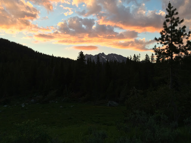
After making sure I had my bear spray handy, I started hiking down towards the creek, with great views of the surrounding mountains.


The suspension bridge is only about a mile from the trailhead, so even though it’s over 500′ down (and then back up again), it’s worth the trip.

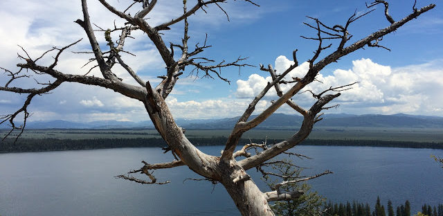
From the bridge, you can see down to the creek, and at the crossing, it’s swift whitewater rapids.

I ended up walking the whole way to the creek. Theoretically you can cross it to combine this hike with another trail for a much longer hike, but while the current is not as deep or swift, it is still at least several feet deep and there are warnings about safe water crossing. Overall, there wasn’t too much to see at the creek, but there were a lot of birds nesting in that area.

After heading back from the creek, it was up, up, up to get back to the trailhead.


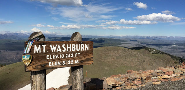
From Hellroaring Creek, I headed to Mount Washburn to attempt my first 10,000′ summit. As part of the Vacation Races series, they have different “clubs” you can join if you do certain things after the race and get a discount on future races. For Yellowstone, one option was the Washburn Club – hiking Mount Washburn within 72 hours of the race and posting a picture with your bib and medal. Challenge accepted!

Throughout Yellowstone, you’ll see hundreds of downed trees and Mount Washburn was no exception.


The good and bad part of this hike is that you can see how much farther you have to go to get to the top. If you squint really hard at the highest peak in the picture below, you can just make out the outline of the observation tower.


The trail is a very wide fire road, which is not accessible to cars, but makes for an easier path to get to the top.


There wasn’t too much snow on the actual road, but as I climbed higher, there were definitely huge snowdrifts.

At the top, you could see almost a full 360 of the mountains and inside the observation tower, there were directional signs to show which mountains you were looking at in the distance.


As I hiked up, I could see some bighorn sheep on the next hillside over and once I was up in the observation deck, I took advantage of the telescope to see them up close.


Despite being a little overexposed, the picture turned out pretty good. I just held my iPhone up to the eyepiece and tried to center it as best I could. Even though I started out in the afternoon, the weather cooperated for me and I got a great view at the top.


There were about 20 or so people at the top of the mountain when I got there, but they quickly dispersed and there was a couple who had also run the race who offered to take my picture at the top, and soon enough, I was the only one left up there. It was pretty cold at the top, so once the sun started to go behind the mountains, I quickly headed back down. As I was coming around a bend, I could see two bighorn sheep near the trail, so I slowly made my way towards them. One of the sheep kept an eye on me and headed into the middle of the trail after I walked down.


This was my first 10,000′ hike and it was definitely tough! The whole hike ended up being a little over 8.5 miles because the fire road was closed down at the base of the hill instead of at the main parking lot, which added an extra 2 miles to the hike. I didn’t get my Garmin started right away, but it was about a 2,000′ elevation gain and loss.


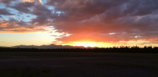
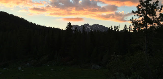
It took me almost 4 hours to do the hike, including a little time spent hanging out at the top. Since I started later in the afternoon, I knew I would be pushing myself to get to the top and chasing the sunset on my way down, but I’m really glad I did it. 

After leaving Mount Washburn, I headed to Roosevelt Lodge for dinner and on my way, I was able to see Rosie and her three cubs – my first bear sighting!


That ended up being my only bear sighting of the trip, so I’m glad I got to see them when (and where) I did.

Westward Adventures – Monument Geyser & Artists Paint Pots

After a quick shower back at my hotel, I headed back into Yellowstone Park. I had reserved a room back at the Hostel in Jackson since I had to return the rental car, so I just wanted to do a few quick stops as I headed back through Yellowstone.

My first stop was Monument Geyser which was a lot harder of a hike than I expected. It was only a 2.4 mile hike total, but half of that was straight uphill and I picked the middle of the day to do the hike, so it was very hot. After the other hikes I did in the park, I think this one can be skipped – there are much better options to see geysers. 

This was also my first real exposure to the sulfur smell of the geysers. You can smell it a little bit as you’re driving through the park, but it’s much stronger as you get close!

This geyser didn’t have much of a “restricted zone” so you could pretty much wander around where you wanted, but it was definitely a good idea to keep an eye on where you stepped.

You can see the steepness of the trail in this picture, as well as some mountains in the background.

My next spot was one I was looking forward to – Artists Paint Pots. There were large boardwalks over the thermal areas, so it was a very easy walk. There were some sections with stairs (very painful after the half!) but it was amazing! 


There were so many different colors, some areas letting out steam or bubbling up – it’s definitely a can’t miss spot on your trip through Yellowstone. It’s only a 1.2 mile lollipop loop and if you can skip the sections with stairs if you want (though you definitely lose the great overarching views from the top). 

Westward adventures – Wandering into Yellowstone

Originally I was planning to be backcountry hiking until Friday, so I wasn’t going to head to West Yellowstone until late Friday afternoon, but since my plans chanced, I went ahead and booked a car from National at 10:00 and figured I would get a head start on the day.*

On my way back from Trapper Lake, I passed two rangers who made made small talk with me, wished me a good hike and then came across a third ranger just behind the first two who stopped me and asked to see my backcountry permit. Less than a quarter mile from the trailhead, so I wasn’t expecting that, but I took off my pack and pulled out the permit which he looked at for a few minutes and then told me, “You really should keep that somewhere more accessible so you don’t have to take off your pack.” True, but I should also have been told that rangers would randomly stop me while I’m hiking and ask to see my permit instead of being told to put the permit on my tent and that rangers may stop by to see them. 

Since I got out of my campsite by 8:00, the morning views on Leigh Lake were even better than the first time!


I ended up getting on the road around 11:30 and headed back through the Tetons to get to Yellowstone. The speed limit as I got closer to Yellowstone dropped to 45 mph and stayed there or below the whole time. I was planning to stop at a visitor’s center and get more information on camping options and recommendations for what to see… and somehow I ended up at Old Faithful before seeing any signs for a visitor’s center, so I decided that even though it was mid-day, I’d check it out. Big mistake! First, it was a Friday, just after lunch and about a third of the parking lots were closed for repair, so it looked like the airport – people inching along hoping they’ll see someone pulling out of a spot and then circling around and around until they can finally get a spot. I did one loop and then immediately headed back out to the main road and decided just to go to the next visitor’s center and ask for more information there. No sign of another visitor’s center, so I just headed into Montana and out the west entrance into West Yellowstone. 
 

I did a quick stop at the race expo and then headed to my hotel for a shower. When I checked into the Super 8, I was the only car in the parking lot and the only other people around were from the KOA next door heating up their food! After a great nap, I grabbed my stuff and headed back into town for dinner before my volunteer shift at the Yellowstone 5k. When I was at the hotel, I asked where I should head for dinner and the woman at the front desk recommended the Wild West Pizzeria & Saloon downtown. Much to my surprise (and delight), it ended up being a Steelers bar!

My friends back home definitely got a kick out of the fact that I was in two random western states and managed to find Steelers fans.

I had volunteered for the Yellowstone 5k earlier in the week because they were still asking for volunteers and were offering 50% off a future race for anyone who helped them out. Since I didn’t have any plans for Friday night (other than sleeping in a real bed), it was an easy choice for me. My role was to help out at the t-shirt exchange at the end of the 5k. The cool part was that we were stationed right at the finish line and got to see everyone come across the line. It was also a perfect evening – sunset over the mountains and lots of cheering for all of the finishers!


After the 5k, I headed back to the hotel and re-arranged all my gear again since I would be living out of the car again for another 3 days after the race.


Up next the Yellowstone Half Marathon race report!

*Notes about National and my adventures trying to leave Jackson Hole
I won’t bore you with all the details, but basically, you’re not allowed to park a personal vehicle on premise, so they told me to go park across the street at a grocery store. When I drove down there, of course there’s a sign that says “no overnight parking” and after talking with the store manager, she confirmed I would be towed if I left my car there overnight and her only suggestion for parking was on the street near the post office. I ended up calling the visitors center and asked them what I could do and they directed me to a parking garage downtown. The good news is that it was free parking for 48 hours, which was an awesome find, but then I had to walk over a mile back to the rental agency to get my new car. This entire process added an extra 1.5 hours into my getting out of Jackson and certainly didn’t put me in a good mood to start my journey. 

Westward adventures – A break into reality and Trapper Lake night #2

Since I unexpectedly stayed at the Colter Bay campground on Wednesday night, I had an easy trek to my first destination of the day – real showers and the laundromat! As I drove the half mile to the laundromat, I saw that there was a lot of fog hanging around the lake, with the mountains peeking out overtop. I knew it wouldn’t last long, so I threw on some shoes and headed out to the same trail I was on a couple days ago.


By the time I actually got to the good mountain views, most of the cloud coverage was gone, but I still walked along the water for awhile and took even more pictures!


After that short side trip, I headed back to take a shower (which was amazing!) and do my laundry. It was nice to have a break and be able to fully charge my phone, catch up on what I had missed over the last 5 days and just generally take a break for a little bit. I finished laundry about lunchtime and headed back to Trapper Lake.

When I got to the Leigh Lake trailhead, I briefly talked to a Ranger who was headed out on the trail. I was still packing up my stuff, but he was sure I would catch up to him at some point on the trail. I did eventually catch up to the Ranger and he offered me a kayak ride if I would help him to get to the north side ranger station. Unfortunately, I didn’t know where that was (especially in relation to where I was going), I’m not a strong swimmer should anything go wrong and it was already starting to get quite warm out, even under the shade of the trees. So, I passed on the offer, but later I found out that the Ranger station was very close to Beartrap Lake, so I would have had about half a mile of hiking to go after that, but I think I still made the right decision based on the information I had at the time.

When I got to camp, the lake looked a lot different with the sun shining over the mountains.


When I first saw the Ranger in the parking lot and told him where I was staying for the night, he told me that the night before there was a bear sighted at Beartrap Lake (the lake about half a mile before my campsite) and to make sure that I kept all of my food in the bear box. So, as soon as I got to camp, I quickly packed all of my extra gear into my very own bear box.


Shortly after I got there, my marmot friends came to visit again.

Since I made it to camp by late afternoon, I set up my tent and decided it was time to take a nap while the sun was so hot. I slept for a little bit and apparently there were a few other folks who took the trail, because at one point I heard someone say, “Look, there’s a tent. I didn’t see that on the way in – it’s well camouflaged.” 

I made another campfire and just spent the night relaxing and watching a beautiful sunset over the mountains.


 Overall, I didn’t end up doing too much on Thursday, but that was intentional since I knew I would be driving up to Yellowstone on Friday and I had a race on Saturday, but it was still a fun day. Sometimes it’s good to build in a little bit of a rest day, especially when you’re on track for an 85-mile week (hiking + a half marathon). 

Westward adventures – Jenny Lake: Hidden Falls & Inspiration Point

After a short delay, I’ve finally started writing about the rest of my trip out west… for the full recap (by day), check out my Westward Adventures page.

Wednesday morning I headed back to the trailhead and got some great views of the mountains that were partially obstructed the afternoon before by the rain showers that came into camp.


After the meadow, I walked back past Leigh Lake, which had great reflections of the mountains in the early morning.


From there, I went back to the Jenny Lake trailhead to start my hikes for the day. First up was Hidden Falls. It was a steep hike and I was (again) glad that I had my hiking poles with me. Even though it was the middle of the week, it was very busy around Jenny Lake, but the hike was definitely worth it.

On my way up to Hidden Falls, I passed a trail that was under construction. Unfortunately for me, it was the trail that goes between Hidden Falls and Inspiration Point. So instead of taking a short hike to my second stop, I backtracked down to the main trail around Jenny Lake and started from the bottom of the Inspiration Point trail.


It was a long and hard hike to the top of Inspiration Point – 7,200′ – but again, very worth it. You could see out across the trees and Jenny Lake and even watch the ferry boat bringing more people across the lake.


After spending some time hanging out on the top of the mountain, I headed back down to the main trail again and instead of going the whole way around Jenny Lake which would have been at least a 15 mile hike (in addition to the 2 miles I had to go to get to my campsite for the night), I just went back the way I came.


As I started my trek around the lake again, I could see the clouds starting to form and could hear some thunder rumbling in the background. At that point, I was glad I made the decision not to go the whole way around the lake so that I could head straight to my campsite for the night.


As I got to the Leigh Lake trailhead it started to rain a little bit, so I quickly re-packed my overnight bag and as I finished, it started to rain a lot harder and the thunder got a lot closer and I started to see some lightning. So, instead of risking hiking through that weather, I hopped back in the car and tried to wait out the storm. The bad part was that the cell reception in the parking lot was really bad, so after about 45 minutes I drove up the road a little bit until I found better reception, took a look at the radar and it looked like there was going to be a break in the storm around 6:00, so I headed back to the trailhead and waited some more. Around 6:15, I decided the weather didn’t look like it was going to get better anytime soon, so I headed back to the Colter Bay campground to stay for the night instead. 

I stopped by the ranger station to let them know I wasn’t staying at Leigh Lake that night and see if there was any way to change my reservation to Leigh Lake for Thursday night. Unfortunately, someone had already booked the last campsite there, so I stuck with my original reservation at Trapper Lake. The bad weather never did hit up at Colter Bay, so I think I made the right decision to head up that way, especially since I was going to end up there Thursday morning anyway.