After a 45 minute drive from the hotel in Bend, we got to the South Sister trailhead around 8:00 and it was only 45 degrees outside. The weather was foggy as we got our gear together and after making sure I had my trekking poles, we set off for a 12-mile round-trip hike to the summit. The initial climb had us trekking through the forest and while there were no blazes on the trail, it was really easy to follow because there was only one path.

After being passed by a group of three 20-somethings who were all wearing shorts and t-shirts, we joked that we clearly came from the south because we were not used to the cool (cold to us) weather. We saw them once more before we exited the woods after they did a little rock climbing off trail, but we quickly lost them after that. The trees were massive and moss was growing on virtually every surface.

After the woods, we came to an exposed area where the rain and wind whipped against us and made the views off the mountain virtually nonexistent.

The fact that it was raining really wasn’t the issue, but the wind was enough to steal whatever warmth generated from the hiking. This is about the time we passed our first person who was coming down the mountain. All he could say that it was too cold and he had to turn around. We kept moving and eventually found a spot with some tree coverage to eat lunch and tend to some blisters before continuing up the mountain.
The terrain on the first 3-4 miles was fairly well-groomed trail with some roots and large rocks, but soon after we passed our second group coming down the mountain, we got into the really rocky trail. The second group also had to turn around because of the weather and said they made it to probably about 8,400′ before heading back down. They did assure us that the trail was really well marked and we shouldn’t have any problems following it as long as we were prepared for the cold and rain. At this point, the fog and rain which had started to dissipate came back in full force and you could see the wind blowing it over the sides of the mountain. The third group we came across said they made it to about 8,600′ before turning around. On we went… up, up, and more up. I was really glad that I had my trekking poles for this part of the climb, and it’s actually the only reason I packed them for this trip at all.

We got to a section that was a mostly a scree field with some good ankle-busting rocks mixed in just for fun. Since we could only see about 50′ in front of us, it wasn’t clear where the trail actually went and looking straight up from where we were, it looked like it was going to be too steep to actually climb. Not having an actual trail map (fail!) made us question whether we were at the right spot, and we could see a clear trail on the mountain to the right, so we went back down the trail and ran into another hiker. Unfortunately, it was his first time at the mountain too, so he wasn’t sure where we were either. All three of us headed back down a little farther and ran into a forth person who also had never been there before. We finally decided we must have been on the trail all along, so the three of us (the last guy turned around) headed back up where we just were and slowly made our way to the top.
I was really struggling on this section of the hike. I could go about 5-10′ and then would have to stop and catch my breath and spent most of my time thinking about how cold I was. Besides the fact I was cold, I think my biggest issue was not taking in enough calories – all I had eaten on the trail was some Cheez-Its, an Uncrustables sandwich (awesome hiking food!) and a peanut butter trail bar – definitely not enough when exerting that much effort.
When we got to the top of that section, we found the three people that had passed us in the beginning of the trail and they looked absolutely frozen! One of them had wrapped a towel around their legs and they were all using extra socks as gloves. We wished them luck as they headed back down and stole their idea of using socks as gloves since we hadn’t brought any either. We had finally made it to the point where we could see Lewis Glacier.

We pressed on until we saw Teardrop Pool, but decided that we weren’t going to be able to see anything at the summit and we were both frozen, so we made the decision to turn around. By this point, I was using my trekking poles to help keep me steady as we stood at the top because the wind was so strong it was threatening to knock me over and the fog had turned into freezing rain / snow, so it was definitely not a pleasant place to hang out.

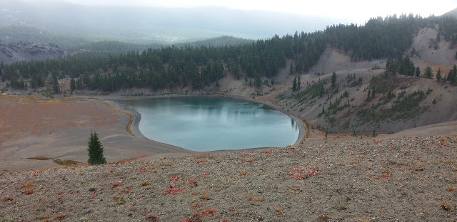
For as hard as it was to climb up the ankle-busting rocks and loose scree, it was even harder to go down. My legs were cold, my hands were cold, the wind was blowing rain into my eyes, so it was very slow going down the steepest section near the top. We stopped again where we had lunch and grabbed some more food which that made things a bit better, along with the fact that it was a much more gentle downhill from there on out. As we passed Moraine Lake, the weather had cleared up a bit again, so there was one last photo op before we high-tailed it back to the trailhead.

After making it back to the car, I got into some dry clothes and exchanged my hiking boots for sandals to ease the pain the new blister on my heel. The rest of the day was spent finding some food (a random restaurant outside of Bend where there were only 3 other people) and driving around the other side of Mt. Hood to Cascade Locks for the night. Once we got down to our starting elevation, around 5,500′ the weather had cleared up and we were able to enjoy it, at least for a little while.

The rainy weather caught back up with us and stuck around for the rest of the evening, so our trek to see the Bridge of the Gods wasn’t as exciting as I was hoping, but it was still neat to see where the Pacific Crest Trail crosses into Washington.

After a long day, it was an early night to get ready for an even longer hike the next day!